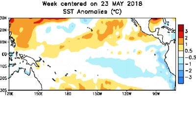
Reuters — Chances of the emergence of the El Nino weather pattern have increased to 65 per cent during the fall and 70 per cent during winter 2018-19, a U.S. government weather forecaster said on Thursday.
The last El Nino, a pattern that brings a warming of ocean surface temperatures in the eastern and central Pacific every few years, was linked to crop damage, fires and flash floods before it went away in 2016.
“The forecaster consensus favours the onset of El Nino during the Northern Hemisphere fall, which would then continue through winter,” the National Weather Service’s Climate Prediction Center (CPC) said in a monthly forecast.
Read Also

Farmers, traders ‘flying blind’ as U.S. shutdown blocks key crop data
U.S. data vital to global grain and soybean trading has gone dark during the country’s federal government shutdown, leaving commodity traders and farmers without crop production estimates, export sales data and market reports during the peak of the autumn harvest.
Last month, the weather forecaster put the chances of El Nino emerging at 50 per cent during the fall and 65 per cent during the winter.
El Nino–Southern Oscillation (ENSO)-neutral conditions are likely to prevail through the Northern Hemisphere this summer, the report said.
Neutral refers to those periods in which neither El Nino nor La Nina is present.
Historically, milder-than-normal winters and springs are known to occur in Western, northwestern and central Canada during El Nino periods, according to Environment Canada.
Eastern and Atlantic Canada aren’t known to be “significantly” impacted by El Nino events, though such an event may reduce tropical cyclone activity in the Atlantic.
— Reporting for Reuters by Arpan Varghese in Bangalore. Includes files from AGCanada.com Network staff.