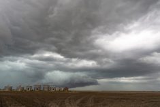
The weather and subsequent forecasts lately have been—to state it simply—a mess. A very active but difficult to forecast pattern has developed across much of Canada and the northern U.S. states. This has brought damp and cool weather to most regions of the Prairies and unfortunately, it looks like this weather will be sticking around at least until the weekend.
I’m going to try my best to paint a picture of what’s going on according to the weather models, but for this forecast period, while the I’m fairly confident in the overall pattern, confidence will not be high in the finer details of the forecast.
Read Also

Mixed year for hail claims across Prairies: CCHA
The 2025 crop year was an average year for hail across the Canadian Prairies, with overall claim numbers down slightly compared to last year, reported the Canadian Crop Hail Association (CCHA).
We start with a broad area of low pressure stretching from central Alberta southeast into Minnesota. This trough is bringing plenty of clouds with showers over central and eastern regions and a mix of showers and snow to western regions. The southern part of this low will move eastward on Wednesday while the northern end will slowly trundle eastwards. This will mean widespread clouds along with scattered showers and flurries over most of the southern half of all three Prairie provinces.
On Thursday and Friday, it looks like this slow-moving area of low pressure looks will gain energy from a system lifting northeastwards out of the central U.S. This will likely bring rain to much of southern and central Manitoba and eastern Saskatchewan before finally moving eastward by Saturday. Cool air will dominate the Prairies, thanks in part to the northerly flow behind this low.
Over the weekend, it looks like we’ll finally see a break in the cloudy, wet weather as weak ridging builds ahead of the next upper low, which will dig along the West Coast. Expect sunny to partly cloudy skies across the Prairies with daytime highs warming back into the upper teens to around twenty by Sunday or Monday.
The digging trough of low pressure off the West Coast is expected to move inland early next week and aid in the development of another large area of low pressure. While this system is a long way off, if it does form, expect widespread showers or areas of rain to impact much of the southern Prairies beginning on Tuesday.
Alberta
Cold, wet and even a snowy start to this forecast period as an upper low interacts with the back end of a trough of low pressure. Southern regions will see the best chance of accumulating snow from this system while central regions will likely only see rain. Amounts and exact locations of the snow are difficult to pinpoint so check local forecasts.
The upper low will begin to move out on Thursday leaving behind a mix of sun and clouds over central regions with southern regions seeing the rain snow mix coming to an end with partly cloudy skies moving in late in the day. Temperatures will remain on the cool side under a fairly strong northerly flow. Expect daytime highs to be around 10 C over central and northern regions while southern regions will only see highs around 5 C.
Over the weekend expect sunny to partly cloudy skies and slowly warming temperatures. Expect daytime highs to be in the 10 to 15 C range by Sunday and the 15 to 20 C by Monday or Tuesday. On Tuesday, if the weather models are correct this far out, attention will have to turn towards the possibility of a large area of low pressure developing over the southwestern U.S. and pushing northeastwards. Should this system develop, widespread rain is forecasted to impact the southern half of the province.
Saskatchewan and Manitoba
As often happens, the general forecast for these two regions is very similar. With a broad trough of low pressure stretching across both provinces, expect more clouds than sun over the next three days. There should be occasional showers and maybe some snow mixing in over western Saskatchewan.
Depending on shower activity, daytime highs should be in the 8 to 12 C range with overnight lows staying above the freezing mark. Late on Thursday, as the main trough is pulling off to the east, the supporting upper low looks to intensify and bring organized rainfall to much of southern Manitoba and eastern Saskatchewan with rainfall amounts possibly reaching 20 mm in some regions.
This low should move off to the northeast on Saturday with sunny to partly cloudy skies working in from west to east during the day. As a weak ridge of high pressure tries to build ahead of the next upper low, expect daytime highs to begin warming up under a southerly flow.
Weather models are showing daytime highs in the mid-teens by Sunday with some low twenties by Monday. These warm temperatures look to be rather short lived as another large area of low pressure is forecast to develop to our southwest and begin pushing northeastwards on Tuesday. Expect increasing clouds from the south on Tuesday with rain moving in late in the day and lasting through Wednesday.
It is a little early to predict amounts as confidence in this system is low, but there is the potential for widespread rainfalls in the 10 to 20 mm range. Depending on timing and any changes to this system’s track and intensity, I will either give an update on Monday or I will put out the weekly forecast a day early than usual next week.
— Daniel Bezte is a teacher by profession with a B.A. (Hon.) in geography, specializing in climatology from the University of Winnipeg. He operates a computerized weather station near Birds Hill Park, Man. Contact him via email with your questions and comments.