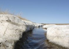
The weather models predicted the end of the cold snap, and we were not disappointed. I wouldn’t quite call it weather whiplash, but temperatures rebounded from overnight lows pushing -40 C to daytime highs pushing well above the freezing mark in the span of the forecast period.
There were hints from the weather models last week that the warm spell might not last long, but in recent days the weather models have leaned towards the mild weather sticking around. The the main medium to long range forecast models are calling for a warmer than average March across the Prairies. Maybe we are seeing an early start to spring.
Read Also

Pulse Weekly: SaskPulse optimistic despite input, crop price concerns
SaskPulse executive director Carl Potts is optimistic ahead of the planting season despite lower crop prices and the war in Iran.
For this forecast period, we have a broad ridge of high pressure building over the western U.S. that is slowly edging into Canada. To our east, there’s a large trough of low pressure over northern Quebec. This means mild weather over the western half of Canada, cold weather over eastern regions, with a bit of a mixed bag of conditions over central regions as the two main systems push back and forth a bit.
Alberta
As I pointed out above, a building ridge of high pressure will bring very spring-like conditions to most of southern and central Alberta at least through the weekend. Expect daytime highs to be in the low to mid teens across southern regions with overnight lows falling to around the freezing mark. Over central regions, daytime highs will be in the 5 to 10 C range with overnight lows falling to around -3 C. Finally, the Peace River regions will see highs in the 2 to 6 C range with overnight lows falling to around -5 C.
Skies over southern and central regions will be sunny to partly cloudy thanks to a building ridge. Far northern regions will likely see some clouds the with chance of flurries or showers on Wednesday and Thursday as a couple of disturbances are forecasted to move in off the Pacific and ride along the top of the ridge. Most of the precipitation from these systems should be confined to the far north and northeastern regions.
By Monday the weather models show the ridge collapsing as a weak area of Arctic high pressure slowly builds south. This high will bring slightly cooler temperatures to start next week with highs across the southern half of the province dropping to around 5 C with highs further north falling to around -2 C. These cool but still seasonably mild temperatures are forecasted to last right through the week with little precipitation expected.
Saskatchewan and Manitoba
Both regions will see temperatures hoovering on either side of the freezing mark over the next several days. A weak disturbance is forecasted to drop southeastwards out of northern Alberta on Thursday , which will bring some clouds and the chance of a few flurries or showers to central Saskatchewan and much of central and southern Manitoba.
A second and stronger area of low pressure is forecasted to quickly follow this system overnight Thursday and through the first half of Friday. Currently it looks like the main snow line will be from north-central Saskatchewan southeast towards Lake of the Woods. There is the potential for a narrow band of heavy snow to develop with this system which could bring between 5 and 10 cm. Due to the speed of this low I don’t think amounts will be much more than this.
High pressure building southwards behind this low will bring a brief period high winds across eastern Saskatchewan early on Friday with blustery conditions moving through southern and central Manitoba during the morning hours. It looks like this system should be out of the region by Friday afternoon. High pressure building in on Saturday should bring a return of sunny skies but cooler temperatures. Expect daytime highs across southern and central Manitoba to be in the -8 C range with Saskatchewan seeing highs in the -4 C range.
The collapsing ridge of high pressure over Western Canada will bring a shot of milder air on Sunday and Monday with daytime highs recovering back to around or slightly above the freezing mark. These mild temperatures look to continue into at least the first half of next week.
— Daniel Bezte is a teacher by profession with a B.A. (Hon.) in geography, specializing in climatology from the University of Winnipeg. He operates a computerized weather station near Birds Hill Park, Man. Contact him via email with your questions and comments.