
Of the many benefits to human well-being provided by wetlands, flood attenuation is an ecosystem service that is receiving more attention.
Now, scientists are working to accurately measure the flood resiliency of well-managed wetlands and grasslands, taking into consideration the value of agricultural management practices that benefit a landscape’s water-holding capacity.
“We’re building better tools to quantify how agricultural landscapes can provide a natural infrastructure potential and then have benefits to the downstream stakeholders, as well as improving the flood and drought resiliency of the agricultural landscapes,” said Steven Frey, senior scientist with Aquanty and adjunct professor at the University of Waterloo.
Read Also

Growing Canada’s beef herd: CCA’s priorities working with new federal government
This is my first column since the federal election. The Canadian Cattle Association works with all elected officials and parliamentarians, regardless…
Frey and his colleagues at Aquanty, a water resource science and technology firm based in Waterloo, Ont., have worked on a number of projects to simulate natural landscapes before development and analyze how they would respond to recent floods, showing how natural landscapes can act as engineered infrastructure would to mitigate floods.
“If [wetlands are] dispersed across the landscape, they can hold a lot of water back and reduce flood peaks,” said Frey, speaking at a recent webinar on beef production and the water cycle, hosted by the Canadian Roundtable for Sustainable Beef.
“These aquatic systems are really very valuable and provide a wealth of services and goods that humans rely on,” said Dave Howerter, senior conservation officer at Ducks Unlimited Canada.
“Unfortunately, recognition of these values have been slow to percolate through society, and we’ve lost a lot of wetlands. Some regions [in southern Canada] have lost 90 per cent of the pre-settlement wetlands, and more than 500,000 hectares of wetlands have been lost in the Canadian Prairies over the last 60 years.”
Frey and his team recently completed a study of Manitoba’s Assiniboine River Basin, which has seen great loss of wetlands in its southern area but is more intact in its northern reaches. They created digital models to simulate the surface and groundwater systems within a 2,000-square kilometre area within this watershed. The models reproduced flooding events that occurred in 2011 and 2014, exploring how flood resiliency is influenced by three management practices: wetland and depression storage, soil permeability and surface roughness.
To evaluate wetland and depression storage, they used three different scenarios in the model: the current landscape, the landscape with 55 per cent more wetlands to illustrate conditions before development and the landscape with an additional 50 per cent of wetland loss and degradation. The scenarios with increased wetland capacity showed a 20 to 25 per cent reduction in flood peak flows when reproducing the 2011 and 2014 floods.
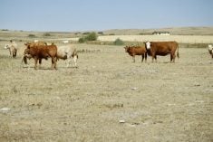
Soil permeability was studied because “a pasture or grassland can do a lot to restore or maintain a healthy soil profile from an infiltration perspective,” said Frey. “The higher permeability allows that water to sit on that landscape to infiltrate and get into the groundwater system, where it can be used in subsequent years.”
For surface roughness, they simulated healthy pastures with high surface roughness, which is known to hold more water, reduce the overland water flow and increase soil infiltration. “Comparing your pasture land to a rolled, ready-to-seed field, that contrast allows a lot more water to be held on the landscape under the more robust land cover, and that reduces flood peaks as well,” he said.
All three practices decreased peak flows during floods, increased the landscape’s water-holding capacity and allowed for greater groundwater recharge in the simulations. These simulations also indicated that these practices enhance a landscape’s resiliency to the effects of drought.
By quantifying this capacity for agricultural landscapes to naturally hold water, Frey believes this will help show the value of wetlands and grasslands for flood attenuation.
“Then using these landscapes for their natural infrastructure potential becomes feasible because we can quantify their behaviour with a stronger sense of security, and this is yielding better understanding of how natural infrastructure associated with agricultural land management decisions can influence all the stakeholders in the watershed,” he explained.
“Ultimately where we want to go is to tie our ability to simulate the influences of the agricultural landscape and natural infrastructure to an economic evaluation, so we can get a true evaluation for what a resilient agricultural landscape means to the broader society.”